Sunday, March 30, 2008

I'm not single!
I know that may disappoint all the ladies of Grand Junction, but just to remind myself that I'm not a single man, my wife flew in for a visit. She was able to stay for almost a week, checking out the area, celebrating our first anniversary, and going to a couple interviews. It was a great time, and now we can focus on doing the big move, and getting her (and our stuff) out here. This is the reason that I haven't posted in a while. Sorry about that.


So Julie flew in, and on Saturday and on Saturday we celebrated our anniversary by driving through the Colorado National Monument, hitting up the local wineries, and going out to a very classy dinner. The pic above is the two of us at the monument. It was a beautiful day, and of course Julie was constantly mentioning how nice it'll be to have her good cameras out here to photograph the area.
As for the wineries, there are over 13 local wineries in the Grand Junction area, with most focused in Palisade. Palisade is also known for it's fruit orchards, so there are a very broad range of wines to choose from. Standards (Chardonays, Cabs, Merlots, Shiraz, Rieslings, etc) to fruity (Cherry, Peach, Plum, Elderberry, Chokecherry) to even Meads. We only made it to 5 before she started feeling tipsy, "I think I'm getting tipsy. I think I'm getting drunk. I think we should stop now." But in her defense, we did have the equivilent of at least 6 glasses of wine each by that point (aka more than a bottle) and up at altitude you get drunk faster. And of course, we were so focused on the drinking, we got no pics from that day. Guess we gotta go back!


Sunday we went skiing (see pic above). We decided that with all the travelling Julie's doing, we'd hit the closest hill to GJ...Powderhorn. It's a little place with only 3 lifts, but plenty of blue cruisers and few fun black runs. Seeing how the weather was wonderfully spring-like, we pretty much stuck to the cruisers and just enjoyed the day. Powderhorn is 45 minutes from our apartment here in GJ, door to door, with free parking, nice small parking lots close to the lifts (again see pic above), and very little crowds. I'll finish with another shot of us from the parking lot showing the beautiful view from the Mesa (Powderhorn is on the Grand Mesa). Of course the pic hardly does it justice, and if you don't believe me, you'll just have to come visit.


Sunday, March 16, 2008

Happy Paint Satricks Day!


Just cause I'm out here by myself, doesn't mean I can't cook up a traditional boiled dinner to celebrate the national holiday of beer, corned beef, cabbage, potatoes, carrots, and some Saint that did something for Ireland.
No I didn't cook up 50 lbs of meat this year. No I didn't have a band rockin the night away. And no I didn't get married or have a good excuse like that. But even in a down year, I still boil up a sweet dinner, polished off a couple Guinni, and watched Boondock Saints.
I mean some traditions can not be broken.
Slainte!

Saturday, March 15, 2008

Since I live here, I might as well go skiing
Whether it's to make my friends jealous, or to apease those looking for pictures, or just cause I like the sport, I finally went skiing again out here. I say again, cause Julie & I did get in a few days during our Christmas visit. But we didn't use two of the tickets for Arapahoe Basin (known as just A-basin) so that's where I went. It's up near Silverthorne, so about 2 1/2 hours from Grand Junction. But when I've already paid for the tickets, it's worth the drive. Especially since my in-laws were willing to put me up for the night, and they live 10 minutes from the hill.
So last Saturday, I got up really early, drove up to Summit County, had breakfast with the inlaws, picked up my ski gear, and hit the mountain. The day was overcast, so pretty flat lighting, but conditions were otherwise excellent as they have been getting dumped on on a weekly basis with fresh snow. For those of you that have been to Abasin before, let me tell you, you need to go back. About a month ago they just opened up this new backside called the Montezuma bowl. It added about 80% to their skiable acre-age. And it's sweet. All blue, black , & double black. Here's a shot from the lift of the double black section on day one, just calling my name.


Obviously you can see how grey the sky was on that day. So take the flat lighting, add in that you have to do a 5 minute hike to get over there, and I wimped out on hitting those runs....on day 1. But I did spend the whole day on the back side, as the other runs back there are awesome.
Day 2: after enjoying a wonderful homecooked dinner sat night, and another nice breakfast sun morning, I was back on the slopes again. Staying so close, I got a nice early start. And the weather was amazing. Here's a shot of most of the Montezuma bowl from the top.


You can't really see the sky there, for how nice the day was, so here are some more shots. First up is that ridge that I said you have to hike to. And yes, on day 2 I did it. Hiked up, skiied along the ridge, dropped in where other skiers were (there's gotta be something like safety in numbers, right?), and made my way down it. It was pretty sweet. If I was in better shape I would've done it more than just once (both the hike with ski gear, and the actually skiing down the steeps takes alot out of you...and I ski with a camelback backpack). You can also see two other ski hills off in the distance: Breckenridge, and Keystone.


OK, so here's another cool shot. I wasn't even trying to do this as a panoramic shot, but I just realized here at home that I could combine these two shots to show you the other side of the Montezuma bowl, and how beautiful the scenery is. Yes I skiied this ridge too. Actually about 3 or 4 times (there was no hiking involved), and you could drop into some wide blues, or ride the ridge all the way to the trees, which some get pretty tight and steep too, but it was all fun.


And the other cool thing about Abasin is the altitude. More than half of the mountain is above tree line. And if you've never skied above treeline, you really should. It's so neat, as it feels like you could ski anywhere. And you probably could, cause there's no trees to define the runs. They groom a few paths, as suggestions of where to ski, but they're just suggestions, as the good snow is off the beaten path (so to speak). And here in the states, everything in bounds is still labeled pretty well, warning you where there's little snow cover (aka rocks sticking out) or where the easy way down is. So I'll close this post with a nice shot of the front side of A basin. Where I did ski for the last hour or so of Day 2 before heading back to the Junction.


So who's coming out to visit next ski season?


Sunday, March 02, 2008

The Arches of Utah


So 30 miles west of Grand Junction on I-70 is Utah. You'd think that with the olympics only 6 years ago, the sign would look newer, but maybe they like it that way. So what's there to do in Utah besides skiing? Well, offroading, and looking at cool geological things in national parks. So I'll save teh offroading for this summer, and start out by hitting Utah's most well known park (that happens to be the closest to me)....the Arches National Park.
I get into the park, grab a map, and drive off. Ignoring a number of scenic view points, cause I wanna see these arches. I mean this whole state is full of scenic views. But I do pull over for something that's not an arch. It's called Balanced Rock. And if you wanna see what a 3500 ton boulder standing on it's end 500 feet off the ground. Well, it's pretty cool.


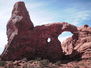
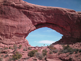
And it's also pretty cool that you park right there (pretty much from where this picture was taken), and can walk right up to it, around it, hope it doesn't fall on you, whatever. So I'm diggin' this park. Bring on the arches. The first ones you come to, are the windows. And you have to notice the people standing in these pictures, just to get some perspective of their size. They're huge. And once again, you can see them from your car, walk right up to and around them. It's really neat.


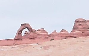
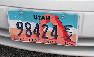
So I'm totally into this right? Next up, the Delicate Arch. That's the biggest deal here. It's the one on the sign when you enter the state. It's on their license plates for cryin out loud. But I got my choice, park and hike a mile up to it (and a mile back, obviously), or park at the "viewing area". Well you know me, less walking the better. So I pick the viewing area, which has two viewing areas. And after mis-reading a map, I walk up a path of stairs, almost half a mile, climbing 200 ft of vertical to get to a spot that I look across a valley at the arch. And you know what, it's ok. Yeah, it's all delicate, and unbalanced looking, but it's not as ginormous as the others. Maybe next time I'll actually hike up to it, and be blown away, but until then, I'm not as impressed as the others.


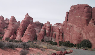
So back to the car and I drive on. I get to the end of the road, and there's the area called Devil's Garden. My first thought, wow these rocks all look like something out of the Flintstones or something. So I gotta get out and see some more. There's a trail map, and at first says: "Total Trail Length = 7 miles". Hell no! But then I see it's labeled green, blue, and red (for difficulty). And I decide that today, I can do the green. And I do, but again, next time I'll come prepared to do some hiking and get to see the rest.


Well, the other purpose of this trip was to do some more cool driving. So one of my coworkers told me of a few roads to try, and let me tell you, I wasn't disappointed. On one road I did have to dodge about 1200 bicyclists, celebrating Moab's Skinny Tire Festival (FYI, Arches Park is right next to Moab). But it was a sweet twisty curvy road along cavern walls on my way to the park. Here's a cool shot of all the turns up ahead, and the cop just waiting for an idiot to floor it and take out a group of bikes.


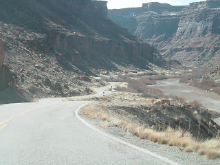
And then on my way back, I took a different route. Around the La Sal mountain, zipping along in the middle of no where, down a 9% slope (which as a frame of reference, for those of you that have driven I-70 up to Summit County, like Breck, and Vail, those roads only get up to 5 & 6% slopes). Into 15 mph corners (taken at about 40 in the zoom-zoom) with no guard rails, and steep drops. Pretty freakin cool and fun to drive. And then as it flattens out into the valleys, I start seeing these signs that I don't understand. "Cattle Guard", hmmm, well, I figured out that those signs marked where a fence that holds in cows has to have a break in the fence as it crosses the road. How well does a fence work, if it has a break in it? And then the sign, "Open Range". Well, as you can guess after you cross a Cattle Guard, you're pretty much driving down a road with a cow pasture on either side of the road, and no fence. And I'll tell you what, as you cruise at the posted speed limit of 65 mph, a site like this kinda takes you by surprise.


And if you look real closely, there's an honest to goodness cowboy, rustlin up this cattle. He just tips his hat at me as I drive by, maybe cause he's friendly, or he could tell that I slowed down to like 20 mph and had a look of fear on my face, thinking I might need to get out and do some Crocodile Dundee mind trick to get one out of my way. And later in my drive, I did come across two more herds (I have a hard time calling less than 10 cows a herd, but I guess that's what they're called) and neither of them had anybody near them. And one cow was actually crossing the road in front of me. I'm too much of a city boy for this.